
Winscombe Archaeology
Part 2. The Roman road between Outer Horseleaze and the Roman mining settlement at Charterhouse
The alignment of the Roman road continues southeast from Outer Horseleaze. Chris Webster of Somerset HER suggests that it is a continuation of a linear feature described in Somerset HER (PRN 11536) as a ‘trackway S of Lippiatt Lane, Shipham’ and which can now be identified as part of PRN 29809, ‘Roman road W of Charterhouse’. This connection between the two sites, means that the line of the road continues to the eastern end of Longbottom Lane where it meets Holloway Lane at ST 4599 5670.
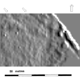
In 2007 ALERT conducted a geophysical survey (resistivity) of Longbottom Camp and the field to the north (fig.4). This work has been re-examined in the light of these recent findings and, unnoticed before, parallel ditches could be seen on the alignment of the Roman road close to Holloway Lane (Fig.5). The ground has been so heavily disturbed in the past that only a short length of road could be seen, but sufficient to confirm its existence.
Figure 4. A lidar image of Longbottom Camp. The area surveyed by ALERT is indicated by a rectangle. This is marked 1 in Figure 7 below.
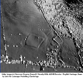
Figure 5. An area north of Longbottom Camp shown as a relief image from the resistivity survey as indicated in Fig.4. Parallel ditches (arrowed) may indicate the line of the road before it joins Holloway Lane to the south.
From this point the line of the road probably led along the valley to the north of Tynings Farm but Forestry work here has likely removed any possibility of locating the course of the road. In May 2006 ALERT surveyed two areas through which it was presumed the road would pass east of Tynings Farm and north of Charterhouse Lane. The first survey of three grids covering an area 90m by 20m identified an area of high resistance at ST 4720 5660 just over 120m north of the lane at ST 476 564. This was precisely on the suspected line of the road. The second survey at ST 476 654 showed a band of high resistance running from west to east about 75m north of the lane (Fig.6 ), again the high resistance was where the line of the road was predicted.
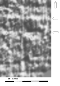
Figure 6. A transect of the line of the Roman road east of Tynings Farm. This is marked 2 in Figure 7 on the right.